A satellite orbiting Earth captured something significant on June 8, 2026. Data from the Sentinel-6 Michael Freilich satellite showed large areas of elevated sea surface height spreading across the central and eastern Pacific Ocean, a reliable physical sign that El Niño had returned and was still growing stronger.
According to Phys.org, NOAA formally declared the El Niño on June 11, after sea surface temperatures in the central and eastern equatorial Pacific measured at least 0.5°C above average for several consecutive months. The natural, recurring phenomenon can have widespread effects, typically bringing wetter conditions to the U.S. Southwest and drought to countries in the western Pacific, such as Indonesia and Australia.
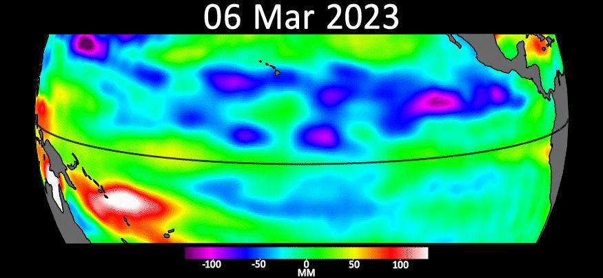
NASA scientists have been tracking the event through sea surface height measurements. When ocean water warms, it expands in volume and causes the sea surface to rise. That physical relationship makes height a dependable indicator of how much heat the ocean is storing. On maps processed by scientists at NASA's Jet Propulsion Laboratory, areas shown in red indicate sea levels running higher than average. White areas show normal conditions. Blue areas are below average.
Earlier in spring 2026, the satellite began detecting precursor signs of the El Niño. Swells of warm water hundreds of miles wide, known as Kelvin waves, moved eastward from the western Pacific. That happens when trade winds in the western equatorial Pacific weaken and then temporarily reverse to blow from the west. Warm water piles up in the east, deepening the warm surface layer, lowering the thermocline, and suppressing the upwelling that usually keeps waters along the Pacific coasts of the Americas cooler.
The distinction between surface temperature and subsurface heat matters to forecasters. A shallow warm layer might not have much impact on climate and weather. A large reservoir of heat stored below the surface can drive stronger and longer-lasting effects. Sea surface height measurements capture that subsurface buildup in a way that temperature readings alone cannot.
JPL sea level researcher Severine Fournier, deputy project scientist for Sentinel-6 Michael Freilich, noted that conditions in the western Pacific on June 8 looked similar to those from the same time in 1997. That was the year an exceptionally strong El Niño emerged, one that produced severe weather disruptions across multiple continents.
The Sentinel-6 Michael Freilich satellite was launched in 2020 through a partnership between NASA and ESA, the European Space Agency. Data from the satellite are processed by scientists at JPL. Signals related to seasonal cycles and long-term trends are removed from the maps to isolate anomalies linked to El Niño and other short-term natural phenomena.
Forecasters and climate scientists will continue monitoring the satellite data in the coming months as the event develops through the Northern Hemisphere summer and into fall, when El Niño conditions tend to reach their peak intensity.