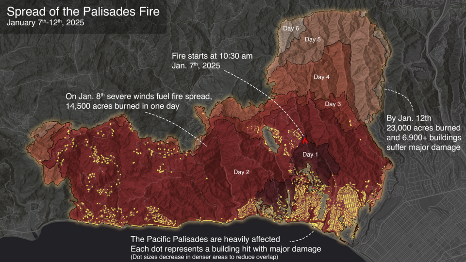
More than 16,000 buildings were destroyed and 31 people died in the 2025 Palisades and Eaton fires in Los Angeles. By the time recovery is complete, the cost could approach a quarter of a trillion dollars. Those fires exposed a gap that researchers have been trying to close for years: existing wildfire models were not built to predict how fires move through cities.
According to a report by Phys.org, the mathematical models used to simulate wildfire spread have largely ignored developed areas. When a simulated fire reached a community in those models, the land was treated as unburnable. Researchers now acknowledge that assumption was wrong, and work is underway to fix it.
"Understanding fire spread between built structures is a totally different equation than understanding fire spread in wildlands," said Michael Gollner, associate professor of mechanical engineering at UC Berkeley. "It's different physics, and until recently, it was not well enough understood to be integrated into the parameters of mathematical models. We still can't do everything at scale, but we've begun to be able to simulate wildfires in urban areas."
The 2025 Palisades fire showed exactly how that physics plays out in a real community. The fire started in the brush of the Santa Monica Mountains, swept through residential neighborhoods in Pacific Palisades, then crossed Mandeville Canyon and burned into other parts of Greater Los Angeles. It moved freely between natural landscape and developed land, exactly the kind of behavior that older models could not account for.
That zone where buildings and natural areas meet is called the wildland-urban interface. Homes in that zone face higher risk, but quantifying that risk has been difficult. California's population has grown from 10 million in 1950 to over 40 million today, and millions of those residents now live in fire-prone areas.
"We are front and center in the wildfire crisis," Gollner said. "California is beautiful, but everything aligns for fires here. We need to learn to adapt, to limit the damage that wildfires cause. A lot of people live in fire-prone areas, and most of the country's major urban wildfire disasters have happened in California."
Historically, much of California burned every 7 to 15 years, a natural process that thinned forests and reduced fuel loads. As development expanded into those areas, that cycle was disrupted. The result is landscapes carrying heavier fuel loads than they historically would have, sitting next to communities with little buffer between them and the fire.
"To make good decisions about the risks communities face, we need more science," Gollner said.