

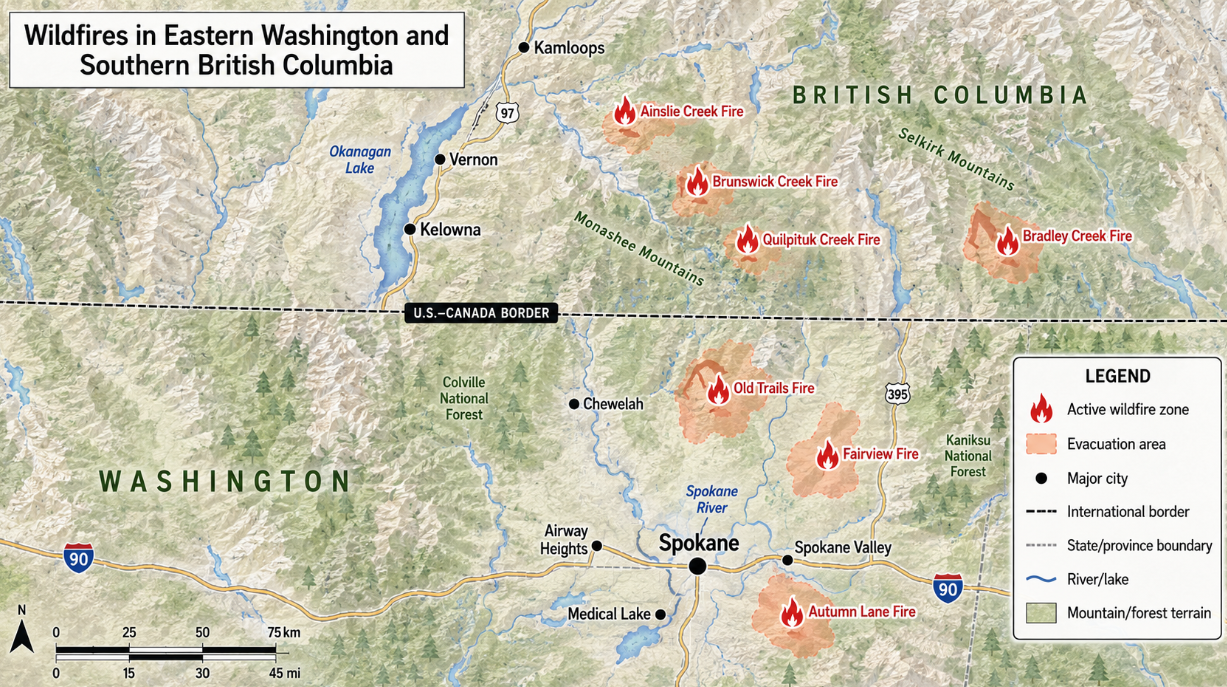
Fast-moving wildfires around Spokane, Washington, have destroyed hundreds of buildings and forced tens of thousands of people to leave their homes. The three fires had burned more than 8,000 acres by Monday, August 3, and remained uncontained. No deaths or serious injuries had been confirmed, but officials warned that searches were continuing.
The Spokane Area Fires include the Old Trails Fire, Fairview Fire, and Autumn Lane Fire. They began on Saturday, August 1, during strong wind, low humidity, extreme heat, and severe drought. Flames moved from grass and forest into neighborhoods with little warning.
About 64,000 residents were ordered to evacuate, according to Reuters. More than 700 buildings were reported destroyed, while infrared surveys suggested that as many as 1,100 structures may have been damaged or lost. Most affected buildings were believed to be homes.
The Spokane fires cover only part of the land burning across Washington.
State officials said more than 250,000 acres were burning in 15 major fires across Washington. At least 390 square miles had burned statewide during the wider outbreak. Other large fires threatened communities, tribal lands, forests, roads, and power systems across central and eastern Washington.
The Old Trails Fire started northwest of Spokane near North Old Trails Road and West Euclid Road. It spread quickly through dry grass and brush, crossed the Spokane River, and reached residential areas. Authorities arrested a 37-year-old man on suspicion of first-degree arson in connection with that fire.
The Spokane County Sheriff’s Office said the arrest followed an investigation involving county detectives and state fire investigators. The suspect had not been convicted, and the case remained under investigation. Officials were still investigating the causes of the Fairview and Autumn Lane fires.
The Associated Press reported that about 1,000 firefighters were working in the Spokane area, with reinforcements expected. Later reports placed the number above 1,100. Firefighters used engines, hand crews, bulldozers, helicopters, and aircraft while protecting homes and helping residents escape.
Unauthorized drones threatened air operations. Spokane County officials said 26 drone incursions were reported over the fire area on Sunday. Fire managers may have to stop aircraft when a drone enters restricted airspace, leaving crews without water or retardant drops.
Cooler temperatures, higher humidity, and thick smoke helped crews Sunday. However, the Autumn Lane Fire remained active overnight. Forecasts called for temperatures to climb into the middle and upper 90s midweek, with humidity falling into the lower teens.
Washington Governor Bob Ferguson declared a statewide wildfire emergency on August 1. His order banned most outdoor and agricultural burning through September 30 and allowed the state to seek crews and equipment through national agreements. The governor also activated members of the Washington National Guard.
The governor’s office said Washington was experiencing its fourth straight statewide drought. More than 1,000 fires had already burned about 425,000 acres in 2026, the largest by that point since 2021. Officials said dry fuels were ready to ignite and spread flames quickly.
The National Weather Service issued a rare Particularly Dangerous Situation Red Flag Warning before the Spokane fires began. The warning covered parts of central and eastern Washington and described a risk of extreme fire behavior and difficult evacuations. Winds later reached speeds strong enough to drive flames across roads, rivers, and fire lines.
Emergency shelters opened at the Spokane Convention Center, Northwood Middle School, and Jenkins High School in Chewelah. The Spokane County Fair and Expo Center accepted recreational vehicles, livestock, and pets. It was also preparing to serve as a base camp for as many as 2,000 firefighters and support workers.
The fires disrupted health care, courts, schools, utilities, and transportation. Twenty-seven patients were moved from the Mann-Grandstaff Veterans Affairs Medical Center after the campus was evacuated. Thousands of utility customers lost electricity as flames damaged equipment and threatened power lines.
Spokane Mayor Lisa Brown called the fires the worst natural disaster the region had faced. Entire streets were reduced to foundations, burned vehicles, and standing chimneys. Some residents returned to find their homes, belongings, and family records gone.
British Columbia was fighting separate wildfires north of the international border. The Canadian fires were not extensions of the Spokane fires, but they were burning under similar drought, heat, and wind conditions. Evacuation orders and alerts covered several communities and First Nations.
The BC Wildfire Service listed the large Ainslie Creek and Brunswick Creek fires as out of control on August 3. Together, those fires had burned more than 48,000 hectares, or about 120,000 acres. Crews were protecting communities, transportation routes, communications equipment, and other infrastructure.
Fires near Okanagan Lake also forced evacuations. More than 2,200 properties were evacuated in the Central Okanagan because of the Quilpituk Creek Fire, while more orders and alerts were issued around the Bradley Creek Fire. Strong winds and a month with little rain helped the fires spread.
Smoke from Washington, Oregon, and British Columbia was expected to affect air quality across the West. Fine particles in wildfire smoke can enter the lungs and bloodstream. Children, older adults, pregnant people, outdoor workers, and people with heart or lung conditions face greater risks.
The United Nations World Meteorological Organization warned in July that developing El Niño conditions could increase the chance of heat waves and other weather extremes. Climate change does not start every wildfire, and ignition sources vary. However, warmer temperatures and longer dry periods can make vegetation easier to burn and allow fires to grow faster.
Residents in evacuation zones were told to follow local orders immediately. Officials advised families to take identification, medicine, water, clothing, important documents, and supplies for pets. Roads can become blocked quickly when many people leave at once.
The full scale of the Spokane disaster was still being measured late Monday night.
Damage teams had not inspected every affected neighborhood, and reports of missing people were still being checked. Containment figures, evacuation boundaries, and structure totals could change as crews gained access. Officials said the immediate goals remained protecting lives, holding fire lines, and preventing new fires during a dangerous season.