

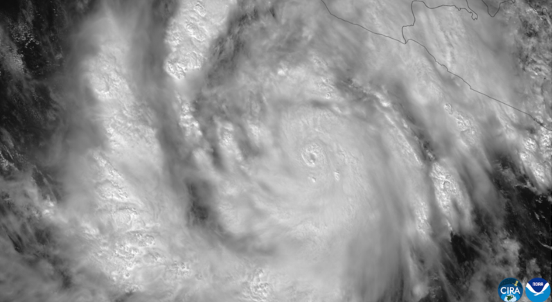
Hurricane Simon remained a powerful Category 4 storm Sunday afternoon as its core moved close to Mexico’s west-central coast, bringing dangerous winds, flooding rain and destructive surf. The storm had weakened from its overnight peak but was still producing life-threatening conditions along parts of Jalisco, Colima and neighboring states.
As of 3 p.m. Central Standard Time on Sunday, the National Hurricane Center said Simon had maximum sustained winds of 130 mph and was about 55 miles south of Cabo Corrientes, Mexico. The hurricane was moving north-northwest at about 6 mph. Earlier in the weekend, Simon reached 155 mph, just below the 157 mph threshold for Category 5 strength.
A Category 4 hurricane has sustained winds from 130 to 156 mph on the Saffir-Simpson Hurricane Wind Scale. Major hurricanes are Category 3 or stronger, beginning at 111 mph.
Simon’s path has shifted enough that forecasters no longer expect an immediate direct landfall along the west-central coast. Instead, the hurricane’s center was forecast to continue skirting the shoreline Sunday evening before moving slightly farther offshore Monday. The National Hurricane Center said the eastern part of Simon’s inner core was still capable of bringing hurricane-force conditions to coastal communities.
The storm’s longer-term track remains uncertain. Forecasters expect Simon to move generally north-northwest for the next couple of days, then gradually turn north and northeast between Tuesday and Wednesday. The latest forecast brings the system back toward Mexico later in the week, but the hurricane center described confidence in that forecast as low.
A hurricane warning remained in effect from Punta San Telmo to El Roblito and for the Islas Marías. A hurricane watch was also issued farther north from El Roblito to Bahía Tempehuaya as officials prepared for the possibility that Simon could approach the coast again later in the week.
Mexican President Claudia Sheinbaum urged people along the Pacific coast to remain indoors and follow civil protection instructions as the storm approached. Nonessential activities were suspended in Jalisco, Colima, Michoacán and Nayarit, while emergency crews, military personnel and local authorities were deployed to threatened areas.
Puerto Vallarta was among the communities preparing for severe conditions. Businesses boarded windows, tourism operators moved visitors toward safer locations and the airport temporarily closed as the storm neared the region. Authorities also carried out precautionary evacuations in vulnerable coastal areas and restricted access to beaches.
Flooding had already been reported in Manzanillo by Sunday as bands of heavy rain moved through the coast. The National Hurricane Center said Simon could still produce an additional 2 to 4 inches of rain in parts of Colima, Jalisco, Nayarit and Sinaloa through early Thursday, with isolated additional totals of 8 inches.
Storm-total rainfall could reach 30 inches in isolated areas of Michoacán, Colima and Jalisco. Forecasters warned that such rainfall could cause life-threatening flash flooding and mudslides, especially in steep terrain where saturated soil can quickly give way.
Storm surge is another major concern. The hurricane center warned of a dangerous rise in water near and east of areas where Simon approaches land, with large and destructive waves expected along the immediate coast. Swells generated by Simon are also expected to create dangerous surf and rip currents along portions of southwestern and west-central Mexico for several days.
Simon strengthened rapidly after developing in the eastern Pacific earlier in the week. Mexico’s National Water Commission reported that the storm reached Category 4 status early Saturday, when it was south of Manzanillo and still intensifying. Its winds later climbed to 155 mph before land interaction and changes in the storm’s inner core began to weaken it.
Forecasters said the nearby Sierra Madre mountains were disrupting Simon’s circulation Sunday. Satellite estimates also showed a shrinking wind field, although the storm remained extremely dangerous. Hurricane-force winds extended outward about 25 miles from the center, while tropical-storm-force winds reached as far as 60 miles.
Simon is the latest in an active stretch of eastern Pacific storms affecting Mexico. Hurricane Polo struck Baja California the previous week as a Category 2 hurricane, while other tropical systems have affected parts of Mexico and the southwestern United States.
The Atlantic basin has also become active. Hurricane Isaias made landfall near Destin, Florida, as a Category 2 storm and later moved into the southeastern United States, causing flooding, wind damage and power outages. That means the original comparison describing Isaias as merely the Atlantic’s first named storm is no longer current.
For residents along Mexico’s Pacific coast, the immediate threat from Simon is not over even though its peak winds have decreased. The National Hurricane Center warned that hurricane conditions, flooding, mudslides, storm surge and dangerous surf could continue affecting the region while the storm remains close to shore.
Forecasters are expected to keep adjusting Simon’s projected track as the hurricane interacts with land and changing atmospheric conditions. The most important guidance for coastal residents remains local evacuation orders, civil protection alerts and updated warnings from Mexican authorities and the National Hurricane Center.