

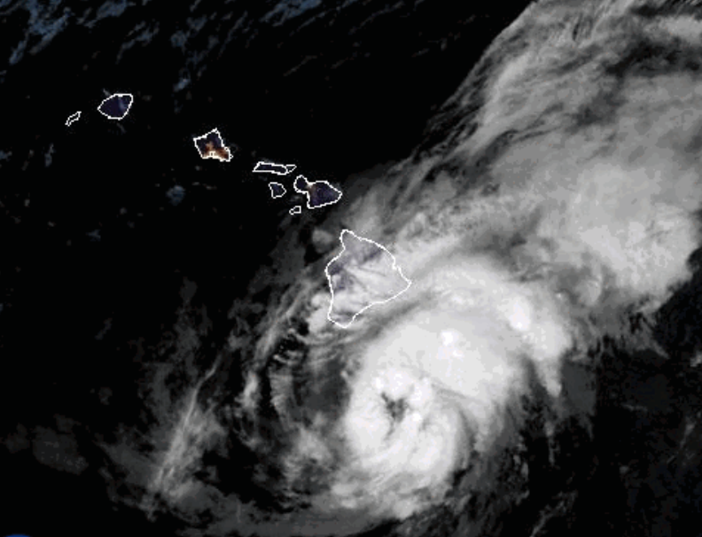
A hurricane warning is in effect for Hawaii's Big Island as Tropical Storm Lala moves toward the islands, with the National Hurricane Center warning that hurricane conditions were expected to arrive by Saturday local time. The storm is forecast to bring extremely heavy rain, flooding, life-threatening surf and rip currents.
According to CBS News, the core of Lala will pass the Big Island on Saturday before reaching south of the smaller islands on Sunday. The storm is expected to weaken as it interacts with the Big Island's terrain, but damaging hurricane-force winds are still forecast, especially across higher elevations. Tropical-storm-force winds are expected across portions of the smaller Hawaiian islands.
Flooding and mudslides are a major concern. In a worst-case scenario, Lala could dump 25 inches of rain onto the Big Island, forecasters at the National Hurricane Center said. The storm could also produce a storm surge as high as 3 feet along the coast, along with large waves and life-threatening rip currents.
Gov. Josh Green addressed the threat in a news briefing Friday night. "This is a very serious storm," he said. "We have not had a hurricane make landfall in quite some time. So none of us really have experienced this really in, you know, the last couple of decades." Green warned that Hawaii will see "an incredible amount of water" and cautioned about the possibility of major power outages. "We're hoping that it's going to be sufficiently far south that we just get the periphery of the storm, but, no promises, we've seen storms turn," he said.
The last hurricane to make landfall in Hawaii was Hurricane Iniki in 1992, a Category 4 storm that caused six deaths and $3 billion in damage, according to Green. Hawaii County Mayor Kimo Alameda told CBS News on Friday morning that the islands are not immune. "We're not exempt from these extreme weather conditions. So we've been here before, and messages have already gone out. But this could look like a big one," he said.
In addition to the hurricane warning for the Big Island, a tropical storm warning is in place for Maui County, including the islands of Maui, Lanai, Molokai and Kahoolawe, as well as Oahu and Kauai County, which includes Kauai and Niihau. Tropical storm conditions are possible in Oahu and Kauai County by Sunday morning.
From NOAA:
...Severe thunderstorm, heavy rainfall, and flash flooding threats
continue along a corridor from the Midwest to the central Appalachians and
across the central High Plains...
...Dangerous heat continues from the Central/Southern Plains to the
Southeast through the weekend, spreading into the Carolinas by Monday...
A locked-in weather pattern will continue to bring various weather hazards
across the country through the weekend and into early next week. An
upper-level high-pressure system will remain entrenched across the
southern tier states east of the Rockies, sustaining the ongoing heatwave
across this region. In fact, the heat is forecast to spread further east
into the Carolinas by Monday as a warm front begins to lift across the
region in response to a developing low-pressure wave passing through the
Great Lakes. Meanwhile, a pronounced mid/upper-level trough over the
western U.S. will slowly progress eastward, as embedded shortwave energy
ejects from the Great Basin and Rockies into the central Plains and
Midwest against the strong upper high. This pattern will continue to
sustain repeated rounds of strong to severe thunderstorms, heavy rainfall,
and flash flooding along a corridor from the Midwest to the central
Appalachians and across the central High Plains to the north of a
meandering front. With saturated soil from previous rainfall and ongoing
flash flooding, a Moderate Risk (level 3/4) of Excessive Rainfall is
maintained for parts of the Midwest to the Ohio Valley today and tonight.
As a low pressure develops and moves eastward across the northern Plains
today, drier and cooler air will spread into the northern Plains and the
upper Midwest on Saturday, shifting the severe storms and flash flooding
threats slightly southward on Sunday for the Ohio Valley with a Moderate
Risk of excessive rainfall in West Virginia. A Slight Risk of excessive
rainfall remains in the forecast for the central/southern High Plains on
Sunday. Some strong to severe thunderstorms could slide across the
Appalachians to reach the Mid-Atlantic region on Sunday.
Across the West, the southwesterly flow will bring monsoonal moisture into
portions of the Interior West, the Four Corners, and central High Plains.
With the combination of instability and sufficient moisture, showers and
thunderstorms will develop across the area through the weekend, especially
during the late-day to overnight hours. Some storms may produce periods of
heavy rainfall, which can lead to flash flooding in vulnerable terrain,
especially burn scars, slot canyons, and urbanized areas. The coverage of
the showers and storms should gradually decrease from west to east over
the next couple of days.