

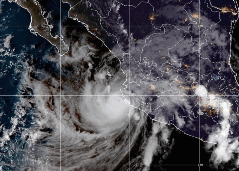
Hurricane Simon weakened to a Category 3 storm Sunday, October 11, 2026, but continued bringing destructive winds, heavy rainfall and flooding to Mexico's Pacific coast. The hurricane remained just offshore as it moved northwest near Jalisco, leaving coastal communities facing dangerous conditions and the threat of additional flooding and landslides.
The storm had maximum sustained winds of 125 mph (205 kilometers per hour) at 6 p.m. local time, according to the U.S. National Hurricane Center. Its center was approximately 110 miles west-northwest of Manzanillo and 50 miles south of Cabo Corrientes, moving northwest at just 5 mph.
Simon had previously reached Category 4 strength with winds approaching 155 mph. Although it weakened Sunday, forecasters warned that the storm remained extremely dangerous, particularly for residents living along the narrow coastal region between the Sierra Madre mountains and the Pacific Ocean.
Mexican President Claudia Sheinbaum urged residents in Jalisco, Colima, Nayarit and Michoacán to remain indoors until authorities declared conditions safe. Emergency shelters opened, evacuations continued and local officials restricted travel as the storm approached vulnerable communities.
Manzanillo Residents Face Flooded Homes and Streets
Heavy rainfall had already caused flooding in Manzanillo, a major port city in Colima state, by Sunday morning.
Residents waded through waterlogged streets as military personnel helped families remove floodwater from their homes. Furniture, appliances and personal belongings were damaged after water entered residential areas overnight.
Reuters spoke with resident Cecilia Palomar, who described extensive flooding inside her family's home. She said beds, refrigerators, stoves and other belongings had been soaked.
Palomar also described the difficulty of persuading her elderly mother to leave. The family moved her to a relative's home on higher ground, although she was reluctant to abandon the property.
The flooding demonstrated that dangerous conditions can develop even when a hurricane's eye remains offshore. Heavy rain bands extending inland can overwhelm drainage systems and produce flooding well away from the storm's center.
Manzanillo had been preparing for Simon since Saturday. Businesses boarded up storefronts, officials closed beaches and civil protection workers warned people to avoid coastal areas.
The port city's exposure to the Pacific makes it vulnerable to both heavy rainfall and destructive waves. Rising water can also complicate access for emergency workers attempting to reach flooded neighborhoods.
Puerto Vallarta Prepares for Dangerous Winds
Farther north, Puerto Vallarta faced the prospect of hurricane conditions as Simon continued moving toward the Jalisco coastline.
The popular tourist destination sits along Banderas Bay, close to Cabo Corrientes, where forecasters identified a particularly serious risk of damaging winds.
Although the storm was traveling nearly parallel to the coast, its circulation extended far beyond the eye. Hurricane-force winds reached approximately 25 miles from the center, while tropical-storm-force winds extended as far as 60 miles.
The Associated Press reported that National Guard vehicles patrolled Puerto Vallarta while police used loudspeakers to direct people away from waterfront areas.
Some residents and tourists continued walking near the shore despite warnings. Officers reminded them that public areas had been closed because of the approaching storm.
Jalisco authorities suspended classes on Friday and Monday in 22 coastal municipalities. Officials also began evacuating people from high-risk communities and instructed hotels to provide safe accommodations for workers and guests.
Tourism businesses prepared emergency arrangements as visitors faced canceled activities, transportation disruptions and uncertainty about their travel plans.
Puerto Vallarta International Airport temporarily closed, creating additional difficulties for travelers attempting to leave the region.
Hotel worker Víctor Martínez told the Associated Press that public transportation had been suspended and much of his workplace evacuated. He said residents were taking precautions more seriously because of previous experience with destructive hurricanes.
The city experienced severe damage from Hurricane Kenna in 2002, an event that remains part of the region's collective memory.
Rainfall Could Reach 30 Inches in Some Areas
Forecasters warned that flooding and landslides could become the storm's most dangerous effects, particularly in mountainous parts of western Mexico.
The National Hurricane Center projected additional rainfall of 2 to 4 inches across portions of Colima, Jalisco, Nayarit and Sinaloa through early Thursday. Isolated areas could receive another 8 inches.
Total rainfall from Simon could reach 30 inches (76 centimeters) in parts of Michoacán, Colima and Jalisco.
Those totals include rain that had already fallen, rather than representing an additional 30 inches expected everywhere.
The Sierra Madre mountains increase the danger because heavy rainfall can quickly flow downhill into rivers, streams and communities below steep slopes.
Flooding can also develop suddenly in narrow valleys and along roads that cross drainage channels. Landslides may block transportation routes, damage buildings or isolate settlements from emergency services.
Residents in low-lying areas face the risk of rising water entering homes, while people living on hillsides must remain alert to unstable ground.
Storm surge presents another threat along exposed sections of the coastline. Powerful winds can push seawater inland, while large waves can damage waterfront structures and make coastal roads unsafe.
The hurricane center warned that dangerous surf conditions could persist even in locations where Simon's center never crosses the shoreline.
Mexico Raises Emergency Alert Levels
Mexican authorities expanded emergency precautions Sunday as the storm approached densely populated and tourist-dependent coastal communities.
Civil protection agencies placed 28 municipalities in Jalisco and Colima under the highest cyclone alert level. Another 93 municipalities were placed under high alert.
The measures reflected concerns about severe weather across a wide area rather than a single possible landfall location.
Emergency shelters opened in threatened communities, while authorities suspended nonessential activities in some locations.
President Sheinbaum urged people to follow instructions from civil protection officials and avoid unnecessary road travel.
Her warning covered four Pacific states where rainfall, flooding and strong winds threatened communities both along the coast and farther inland.
Officials were particularly concerned about people living in flood-prone neighborhoods, informal settlements and areas exposed to landslides.
The emergency response also involved coordination with hotels and tourism businesses because large numbers of visitors were staying along the threatened coastline.
Authorities continued to assess which neighborhoods required evacuation as river levels rose and weather conditions changed.
Simon's Track Remains Important
The hurricane's slow northwestward movement created uncertainty about which coastal communities would experience the strongest winds.
Earlier forecasts had raised the possibility that Simon could make landfall along Mexico's west-central coast. By Sunday evening, its center remained offshore, although damaging conditions were already affecting communities on land.
Forecasters expected Simon to weaken further as it interacted with the mountainous coastline and changing atmospheric conditions.
The National Hurricane Center said the storm was expected to move farther offshore Monday before potentially turning back toward Mexico's coast later in the week.
Its track remained important because relatively small shifts could change which communities received the most intense wind, rainfall and coastal flooding.
Simon arrived shortly after Hurricane Polo struck Mexico's Baja California Peninsula, damaging infrastructure and causing flooding.
The two storms have added pressure to emergency services during an active Pacific hurricane season.
For communities along the Jalisco and Colima coasts, the immediate concern remains the combination of saturated ground, rising water and potentially destructive winds.
Although Simon weakened from Category 4 to Category 3 on Sunday, the reduction in wind speed did not eliminate the flooding danger. Officials continued urging residents and tourists to remain sheltered while emergency teams monitored the hurricane's progress and assessed damage along the Pacific coastline.